Licence 01
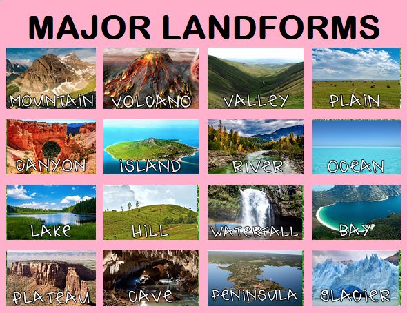
Geomorphology is the branch of physical geography that studies landforms on the Earth’s surface and the processes that shape them. It examines how mountains, valleys, plains, rivers, deserts, glaciers, and coastlines are formed and how they change over time. These landforms are created by the interaction of internal forces, such as tectonic movements and volcanism, and external forces, such as weathering, erosion, transportation, and deposition. Geomorphology also uses geological history and modern scientific techniques to understand past, present, and future landscape evolution. The subject is important for understanding natural hazards, environmental change, resource management, and human–environment relationships.
- معلم: BELFAR DALILA
Earth Science is the scientific study of the Earth—its materials, structure, processes, and history—and how it interacts with the atmosphere, oceans, living organisms, and the universe.
Earth Science provides foundational knowledge that helps students understand how our planet works and why natural phenomena occur.
- معلم: BELFAR DALILA
Geologists study the Earth’s structure, materials, and the processes shaping them, both past and present. As a scientific discipline, geology uses deductive reasoning and scientific methods. It is highly interdisciplinary, involving knowledge from physics, chemistry, biology, mathematics, and astronomy.
- معلم: BELFAR DALILA
This course is intended for first-year students in earth sciences.
This course is structured according to the national curriculum in five chapters.
BASIC DEFINITIONS
I.THE GEOLOGICAL MAP: 1 - Land rating: a) sedimentary lands, b) magmatic terrains c) metamorphic terrains
2 - Notation of structures
3 - Other conventional signs
4 - Geological map notice
II. THE GEOLOGICAL CUT: 1- principle, 2- Conventional figures
III. GEOMETRIC PROPERTIES OF LAYERS: 1- Dip and direction of a layer, 2 - Actual and apparent thickness
IV. REPRESENTATION OF GEOLOGICAL LAYERS
V. GEOLOGICAL STRUCTURES: 1- Tabular structures, 2- Monoclinal structures, 3- Pleated structures, 4- Faulted structures, 5- Discordant structures
- معلم: MOUICI RIDHA